
Efficient radiometric surveying for mineral exploration
Radai’s drone-based radiometric survey system provides a fast, flexible and cost-efficient solution for mineral exploration and geological mapping. The system measures naturally occurring gamma radiation associated with potassium (K), uranium (U) and thorium (Th) in rocks, soils and sediments. Variations in these elements provide valuable information about geological conditions and soil composition and can support mineral exploration and site characterization.
By integrating radiometric measurements with a UAV platform, Radai combines the detailed coverage of low-altitude surveying with the efficiency of airborne data acquisition. Compared with traditional ground surveys or conventional aircraft, drone-based measurements can reduce fieldwork, improve access to difficult terrain and make detailed surveys economically feasible for smaller or targeted exploration areas. The brochure highlights lower costs, faster acquisition and improved measurement detail as key advantages of UAV-based radiometric surveying.
Applications in mineral exploration
Radai’s radiometric system can support different stages of exploration and mining. Its main applications include:
- Mineral exploration and geological mapping – mapping spatial variations in K, U and Th to support geological interpretation and identification of areas for further investigation.
- Soil and regolith characterization – providing information about variations in soils, sediments and near-surface geological materials.
- Exploration targeting – adding radiometric information to geological, geochemical and other geophysical datasets to improve target definition and prioritization.
- Mine-site mapping and monitoring – supporting 3D mapping, geotechnical characterization, slope and subsidence monitoring and other site investigations.
- Mine tailings and environmental monitoring – supporting monitoring of tailings areas, acid mine drainage, recultivation and environmental conditions.
- Abandoned and inaccessible mining areas – collecting information from locations where ground access may be difficult or unsafe.
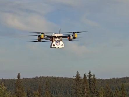
Basic parameters:
Frame 1320mm
Prop. 8x 30′ (tip to tip 197cm)
Fuselage height 37cm
Flight weight 24,9kg
Material: carbon fibre and plastic
Motors 8
Max.power 16kw
Payload:
Max. takeoff weight: 24,9kg
Max. payload: 7kg
Flight:
Max altitude 2000m
Max wind resistance 12m/s
Range with 7kg payload at 8,5m/s 35km
Customer benefits
The main advantage for customers is the ability to obtain detailed geophysical information quickly and with reduced operational effort. Low-altitude UAV surveying enables systematic coverage while limiting the need for personnel to traverse difficult terrain. This is particularly valuable in remote, steep, vegetated, abandoned or potentially hazardous areas.
Drone deployment also provides considerable operational flexibility. Surveys can be mobilized rapidly, targeted to specific exploration areas and repeated when additional measurements are required. The resulting radiometric datasets can complement other exploration methods and help exploration teams focus subsequent geological mapping, sampling or geophysical investigations on the most relevant areas.
For customers, this translates into faster data acquisition, reduced field exposure, lower survey costs and more efficient exploration decision-making.