Radai Oy, in co-operation with Beak Consultants GmbH, can support mineral exploration companies in preparing prospectivity maps of mineral occurrences for greenfield or brownfield exploration. Radai and Beak can analyze all types of geophysical, geochemical, and geological data with data mining software using artificial intelligence in a GIS integrated platform and develop predictive maps of any exploration licensed area. The advangeo® Prediction Software by Beak uses a data-driven modeling approach based on artificial intelligence algorithms that can be used to make both qualitative and quantitative predictions. The “Minerals” extension assists the user in each step from data preparation, model generation to the creation of forecast calculations.
Contact info: Ari Saartenoja, CEO, Email: ari.saartenoja@radai.fi, Tel.: +358-45-1653443
Ina Storch, Software Sales, Email: ina.storch@beak.de, Tel.: +49-3731-78136
Case Study: Kupukka
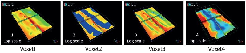
Provided 3D Geophysical Data
Voxet1: Amplitude of the magnetization vector (Sqrt((Voxet2)²+(Voxet3)²))
Voxet2: Length of the magnetization vector in the earth’s mag field direction
Voxet3: Length of the magnetization vector perpendicular to the earth’s mag field
Voxet4: Log10 of the resistivity based to Radai’s Drone-EM data. Inversion by GTK
Voxet5: Log10 of the resistivity based to GTK’s airborne EM data. Inversion by Radai
Voxet6: Average of 4 and 5.
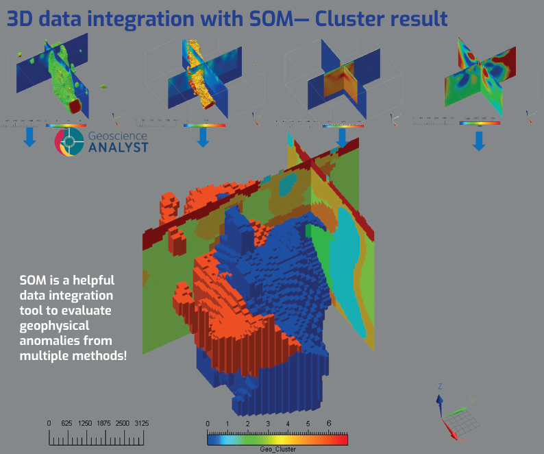
SOM model
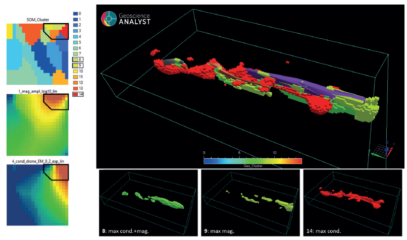
Different models were run with varying input data. As an example, SOM clustering of model 19 was based on Voxet1 (3D amplitude of the magnetization vector, log10 scaled) and Voxet4 (3D resistivity from Radai’s Drone-EM data, 3D inversion by GTK) as input. Three clusters of interest were identified from model 19 shown below: no. 8 with high magnetic and conductivity anomaly, no. 9 with high magnetic, and no. 14 with high conductivity anomaly only. Isosurfaces in the 3D plot show the geological constraint used in magnetic inversion.